Inside Xunantunich: A Complete Guide to Every Structure, Plaza and Frieze
Short answer. Walk in from the visitor centre, take Plaza A-I first and El Castillo last, and give the frieze ten minutes from a distance rather than two from underneath. Three hours covers the outer groups as well; two covers the main precinct.
Xunantunich is small enough to walk in an afternoon and dense enough to reward doing it in order. This is that order, structure by structure, with what each one is and what to look for. Xunantunich Mayan Ruins tours that allow three hours give you time for all of it; the one-hour slots do not.
Overview: how the site is laid out
The centre is one main precinct on a levelled limestone ridge, with three outlying groups around it. NICH's own plan board at the entrance marks Plazas A-I, A-II and A-III, a smaller plaza, an aguada — a reservoir — and Groups B, C and D. The whole restored core fits inside a comfortable circuit.
Allow two hours for the main precinct including the climb, three if you want the outer groups. The structures page carries the same buildings as reference entries; this is the walking version.
Plaza A-I, where the scale registers
The main ceremonial plaza, closed at its southern end by El Castillo. Grass underfoot, structures on three sides, and the ridge dropping away behind. Stand at the northern end before you walk in: from there the pyramid reads at its full height, and it is the shot almost everybody wants and takes from too close.
Time to spend: twenty minutes, and come back through it on the way out.
Structure A-9, and the tomb under it
On the eastern side of Plaza A-I. It looks unremarkable, and it held the largest Maya burial chamber found in Belize in a century of digging — opened in 2016 by Jaime Awe and the BVAR project. Inside were an adult male aged twenty to thirty, 36 ceramic vessels, a jade necklace, 14 obsidian blades and deer or jaguar remains.
Two carved panels came out of the same excavation, and they had come from somewhere else: a ceremonial staircase commissioned at Caracol in 642 CE. The full story is in the surprising-facts post.
Time to spend: five minutes, and ask your guide to point out where the tomb was.
El Castillo — Structure A-6
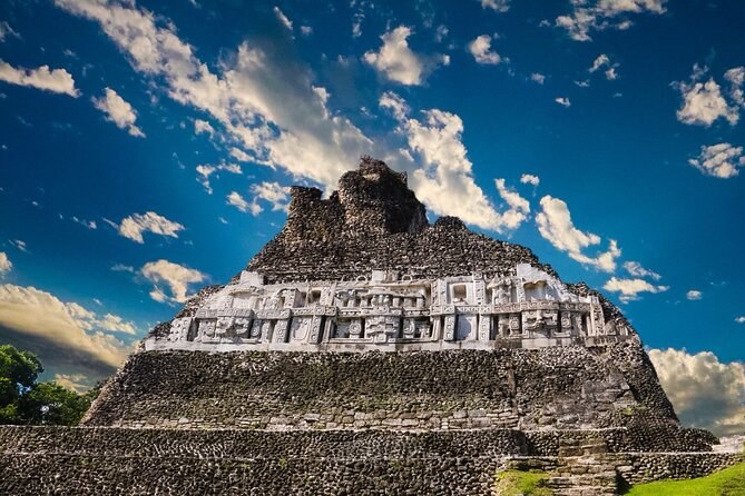
130 feet and 40 metres above the plaza floor, the second-tallest structure in Belize after Caana at Caracol, and the reason nearly everybody comes. Its upper levels went up in two phases, around 800 and around 900 CE, and the later phase buried most of the earlier frieze.
You climb it by a sequence of stone stairs and terraces. It is broken into enough stages that most people manage it comfortably — travellers in their seventies report doing it — but the steps are worn and there is no shade at the top. The view runs west over the Belize River valley and into Guatemala.
Time to spend: forty-five minutes including the climb and time at the top.
The frieze, and why what you photograph is a copy
A band of modelled stucco that once wrapped all four sides of the upper temple's roof panel. Fragments survive on the east and the west. What stands there now is a replica: the originals are sealed underneath for their own protection, and the Getty Conservation Institute worked on them between 1992 and 1996.
The east frieze shows a World Tree, the sun god, the moon and Venus, with Chaac — the rain god — probably at the centre.
💡 Useful Tip Step back to the far side of the terrace before you photograph the frieze. From directly beneath, the figures foreshorten into a texture; from fifteen metres out in low morning light they resolve into faces and glyph blocks.
Time to spend: ten minutes, twice — once on the way up and once on the way down, because the light changes.
Structure A-1 and Plaza A-II
A range building between the two plazas, raised with A-13 only in the ninth century. It is the most interesting piece of architecture on the site for anyone who cares about why places end: archaeologists read it as the ruling family closing its own space off from everyone else's as the Classic order came apart. The history page sets out the argument.
Time to spend: ten minutes, standing on the A-I side and looking through the gap.
Groups B, C and D
Three further architectural groups beyond the restored precinct, marked on the plan board and mostly unvisited. They are unrestored, so what you get is mounds and edges rather than standing walls. Worth the walk only if you have booked three hours.
Time to spend: thirty minutes if you have them to spare.
What the visitor centre is worth
Ten minutes, at the start rather than the end. The plan board outside is the single most useful thing on the site: it marks the plazas, the aguada and Groups B, C and D, and it gives you the shape of what you are about to walk. There are restrooms, a picnic area and free parking here, and this is the last of all three until you come back down.
It is also the honest measure of how little interpretation the site itself carries. Once you leave the centre you are looking at unlabelled stone, which is the whole argument for walking it with somebody who can read it.
Where the climb gets steep, and what to do about it
The first two thirds of El Castillo are terraced and straightforward. The upper section is narrower, the treads are more worn, and there is more exposure. Take it in stages, use the terraces as landings, and go up on the side with the handrail.
Coming down is harder than going up on worn stone, particularly in the wet. Face the stairs rather than the view on the steepest section and it stops being a problem. Nobody has to reach the summit to have seen the building — the terrace below the frieze gives you most of the view and all of the carving.
Hidden highlights most visitors walk past
- The aguada. The reservoir marked on the plan; how a hilltop city with no river at the top held water.
- The chamber openings on El Castillo. Dark rectangles in the upper levels, and the reason the pyramid reads as a building rather than a mound.
- The wildlife. Howler and spider monkeys, iguanas and coatis are all common. Look up at the tree line rather than down at the stones.
- The view line into Guatemala. From the top, the town on the horizon is Melchor de Mencos, across the border.
The walking route, in order
| Order | Where | Allow |
|---|---|---|
| 1 | Visitor centre and the plan board | 10 min |
| 2 | Plaza A-I, from the north end | 20 min |
| 3 | Structure A-9 | 5 min |
| 4 | Structure A-1 and Plaza A-II | 10 min |
| 5 | El Castillo — climb, frieze, summit | 45 min |
| 6 | Groups B, C and D (optional) | 30 min |
| 7 | Back through Plaza A-I | 10 min |
Photography, and when the light works
Early morning for the frieze and for the pyramid front-on; late afternoon for the plazas. Midday flattens everything and there is nowhere to stand out of the sun. If photography is the point of your visit, take a morning departure and be on the first ferry — the weather page has the seasonal detail.
A guide is what turns this list of buildings into a city. NICH sets a ratio of one guide to a maximum of fifteen visitors, and guides wait at the crossing for about US$30 for two people if you would rather hire on the day. Xunantunich Tours compares the departures that include one, and shows which give you the three hours this route needs.
Tours that give you three hours on the ridge
Private Tour to Maya Sites Xunantunich and Cahal Pech
PrivateFees includedHotel pickup
From $175 per person
Xunantunich Maya Temple and Jungle River Cave Tubing Combo Tour
Max 45LunchFees included
From $155 per person